komoot: The Most Powerful Route Planning App For Bikepacking & Cycle Touring?


Full disclosure: komoot provided financial support for my 2018 tour of Armenia, and I published this review as part of that agreement. In 2023 I updated the post to reflect the app’s evolution.

Lots of people have been asking about the route planning and navigation apps I’ve been using on my recent bike tours. 

The app I’ve mostly been using since 2018 is komoot (with a lowercase ‘k’), the creation of a Berlin-based team of developers, which is finding increasing favour with recreational outdoor users – and it also happens to be an excellent route planning and navigation tool for cycle tourists and bikepackers.

First things first, though: why use any route planning and navigation app, rather than a simple map, on a cycle tour or bikepacking trip?

Finding your way on a bike trip has long been done by some process of looking at maps, comparing them to what you see around you, and piecing together a cycling-friendly route from there. But apps like komoot are now clever enough to calculate – in many cases – consistently better routes than those you might pick yourself.

By “better”, I don’t mean shorter or more direct, like Google Maps or your friendly roadside truck driver might suggest. I mean quieter, prettier, with gentler gradients and road surfaces appropriate to the bike you’re riding, and passing by more points of interest along the way – in short, routes that are better for cyclists.

This kind of functionality used to be hard to achieve. Simply put, the underlying data wasn’t good enough – which was why I never bothered with previous generations of these apps and websites. It was also because I generally like to go low-tech and keep things simple.

But times have changed. The coverage and accuracy of open-source global mapping data continues to skyrocket, and the body of community-created routes is growing in parallel.

On my cycle tour of Armenia in 2018, I had a list of specific places I wanted to visit. So I decided to give komoot a try to see if it would make reaching them more enjoyable.

The komoot app itself (Android/iOS) is free, as is the first of the regions you download. From then on, additional regions are chargeable at EUR3.99 each, but ultra long-haul riders might prefer to buy the world pack (EUR29.99) which covers the globe for a one-off lifetime purchase.

After using komoot daily for that month-long ride the length of Armenia, my overall impressions were very positive. Those impressions form the basis of the rest of this review. 

There were a couple of issues which I’ll mention in detail below, but none were deal-breakers. Indeed, komoot has since become my go-to app for route planning and navigation on most of my cycle tours and bikepacking trips, as you’ll see from the hundreds of tours on my profile I’ve recorded and shared since.

So what exactly are komoot’s strengths? 

To my mind, it isn’t a single feature but rather the package as a whole. Rather than trying to do everything for everyone and cram in every possible piece of functionality, the developers’ goal seems to be simplicity of use combined with powerful core features. 

To that end, the app’s functionality is broadly split into three parts: route planning, navigation, and community. Let’s go through each in turn.

Planning mode uses routing algorithms to generate optimal routes between any number of points of your choice, which can be searched for, selected on the map, chosen from categorised listings of nearby places, or chosen from community recommendations. The routing happens server-side; you’ll need an active internet connection to carry out this step, but saved routes can then be followed offline.

The resulting routes are generally excellent – I particularly like that you can switch between cycle touring, road biking, gravel biking and mountain biking, which produce different routes based on different criteria – and the database of points of interest is extremely comprehensive.

Of particular use to cycle tourists and bikepackers is that generated routes are displayed not just with elevation and gradient profiles but also track type breakdowns, so you can see in advance what proportions of a route are on dirt or asphalt, highway or provincial road, etc, and adjust as necessary depending your preferences. Also generated are statistics concerning distance, estimated ride duration based on your fitness, total ascent/descent, average grade, highest/lowest elevations, and the like (though in uber-mountainous Armenia these numbers usually give me a sinking feeling!).

It’s worth mentioning that komoot has a web interface for planning routes with a bit more screen real-estate. Routes planned here are then saved to your profile and synced to the app.

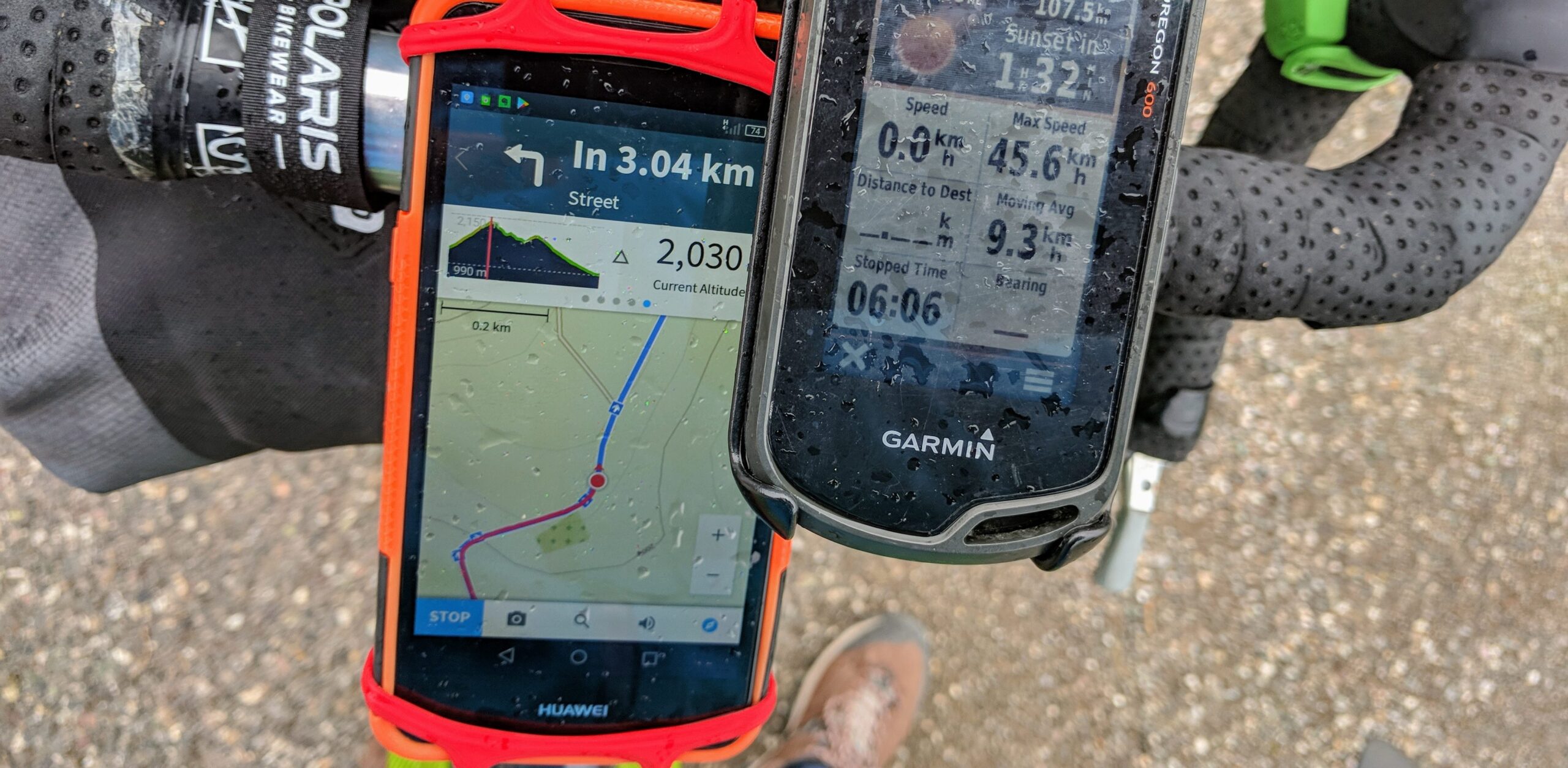
In navigation mode, the app is unobtrusive and as accurate as the mapping allows (see below); I prefer to use the audio prompts (turn-by-turn navigation) with the screen switched off, which saves a lot of battery power. The fact that this works offline for pre-planned routes is a big plus. Your actual route is automagically logged, regardless of whether it matches the route you planned, and can later be exported as a GPX file.

Although every platform now has some implementation of the idea, perhaps the most innovative feature when komoot was first launched was the community aspect of the platform. 

Once you’ve logged your day’s activities, you are encouraged to highlight your favourite spots and sections on the route, and then to share any resulting recommendations with the app’s other users, who can then upvote them. Popular highlights then begin to show up when other users plan routes in the same area, thus enabling them to benefit from good recommendations. Public trips also become searchable and show up on your profile.

You can also embed them in your blog:

The result is a crowdsourced database of routes and curated highlights which might not appear on a regular basemap. (On a gamification tip, you also get badges and whatnot for being an active contributor.)

It’s a nice, simple system that seems to have the spirit of exploration at its core, rather than that of competition or showmanship as with some other cycling apps. Does it work? Well, the app has 5 million users at the time of writing, so komoot must be doing something right!

I mentioned earlier that there are caveats. komoot asked for an honest report, so here they are in detail.

The most visible issue stems from the app’s reliance on the OpenStreetMap database and open-source elevation data to provide the underlying data. All of the route planning features depend on it. This means that the functionality will only ever be as good as the data. And while the open-source data is extraordinarily good in some places (including the app’s native Germany, the UK, and most other European countries that dominate its user base), in Armenia it is far from perfect.

To be sure, it’s a lot better than it was – my team added or updated more than 5,000km of track data in 2016 alone as part of the Transcaucasian Expedition – but there are still quirks, mostly relating to road names (which affect the audio prompts), the misclassification of dirt roads as paved (which affects routing for road biking), and the low-resolution elevation model (which creates discrepancies in elevation and gradient profiles).

Of course, komoot is by no means alone in suffering from incomplete or inaccurate mapping data. In fact, the same issues affect all apps using OpenStreetMap (which is most of them). But coverage and accuracy continues to improve worldwide, and a bit of common sense is enough to overcome most routing issues – and it’s practically a non-issue in much of Europe nowadays. That’s why it isn’t a deal-breaker. The fact that it even has such sophisticated routing features is already a game changer – find me an app five years ago that could do that!

And if the map really is blank at any point, you can draw a straight line between A and B, or switch the basemap to aerial imagery and trace the routes you see. This much-requested new feature is called ‘off-grid routing’ and surfaced in an update midway through the ride on which this report is based. It gave komoot a big leg-up in the planning of intrepid, off-trail routes.

On the topic of routing, komoot does have a particular type of user in mind with these features. While the algorithm is extremely powerful if given good data, users who like to do their own fine-grained route planning will find the algorithm too dominant. Adding additional points to ‘force’ the app to take the route you want is clunky and cumbersome.

But this would be missing the point: komoot’s focus is clearly on making the routing feature as strong as it can possibly be and appealing to people who will utilise it, rather than override it.

(Case in point: I’ve found plenty of new routes in Armenia that I wouldn’t have known about had I not followed the app’s suggestions.)

There are a few minor issues that could be improved (or at least there were when this report was originally published):

  • It is hard to add new points to a route mid ride. I’d prefer to see pre-selected categories of points on the map at all times, and then simply tap to add them.
  • I’d like to be able to join a pre-planned route midway while offline, rather than replanning it with a new starting point, which needs an internet connection.
  • If I make an intentional detour, I’d like the app to recognise this rather than instructing me to make a U‑turn for the next several minutes.
  • If I’m going (downhill?) too fast to be able to hear the audio prompts, it would be cool if the app would detect this and show a visual prompt as well.
  • And if my phone’s screen is locked, I would prefer to be able to unlock it without pausing my tour to do so.

The specific phone I used during testing – a cheap Huawei Y6 – also has a habit of terminating the app at unpredictable intervals when the screen is off. Having looked into the issue I believe it is an issue with Huawei’s proprietary version of Android, rather than a fault with the app itself. It doesn’t happen with my Google Nexus 6P, which runs the regular flavour of Android, nor my later Pixel 4 XL.

Finally, I don’t believe I’ve got the best out of the social features, purely because of where in the world I’m located. I became a komoot Pioneer in Armenia by default because nobody else was using it.

The verdict?

komoot is certainly the most powerful route planning app for cycle touring and bikepacking I’ve come across to date, as long as you let it do its thing and don’t try too hard to override it. And if you’re cycle touring in new places and you don’t know the area, who wouldn’t want optimally calculated routes together with curated community highlights?

Throw in offline voice-assisted navigation and you’ve got one of the most powerful apps a cycle tourist could wish for. Just check OpenStreetMap coverage of the region before you commit.


If you’re keen to see how it actually works, check out my public komoot profile, which includes all my tracked rides (and a few hikes) in Armenia so far.

Comments (skip to respond)

28 responses to “komoot: The Most Powerful Route Planning App For Bikepacking & Cycle Touring?”

  1. Da Long avatar
    Da Long

    The World Package is anything but. I live in China and it has no coverage whatsoever. Maybe they should rename it to ‘First World Package’.

    Google Maps [with a VPN] is much more useful.

    1. Komoot, like most comparable apps, uses the OpenStreetMap database to generate its maps. OpenStreetMap itself is built on user contributions. In other words, it’s crowdsourced. So if a country or region has poor mapping, it isn’t really the fault of Komoot or any other app that uses this database.

      OpenStreetMap coverage was also poor where I live, so I’ve spent several years improving it myself so I and others can benefit from apps like Komoot which use that data.

  2. Christian avatar
    Christian

    I’m also using RWGPS, and all the routes on bikepacking.com are on that app. Any comments on the differences and whether komoot is better for trails and remote regions?

    1. Having used both, in general I find the desktop/web interface for RWGPS better for detailed route planning in remote areas, but for routefinding and navigating on the fly I much prefer komoot’s simplicity. They both use the same database (OpenStreetMap) so most else comes down to the quality of the map data.

  3. dogs boy avatar

    I’ve used komopt for a season and several tors, including a remote moutianous one where elevation was important. Komopt at the time was wonderful, keeping me oriented moment to moment.

    But then they introduced monthly premi pricing, and things have gone to hell.

    Pay your $3/month or no terrain or elevation data. Rendering the software basically useless for touring.

    Will be reconsideringy options this coming touring year.

    1. I’m looking at the komoot website pricing page right now and there’s no mention of any monthly payments. You can pay per region for offline navigation functionality, which is a one-off purchase with ‘free updates for life’, and you get one free region when you signup. That’s been the pricing model for at least the last 2 years. So I’m not sure what you’re referring to with ‘monthly premium pricing’. Am I missing something?

      1. Hi Tom,

        komoot also offers a Komoot Premium monthly subscription product that as well as a bunch of other nice to haves, includes “The World” region offline maps https://www.komoot.com/product . Confusion is arising from that I’d guess. 

        Nice article. Been a long distrance off-road user of RideWithGPS for a while. Evaluated komoot a few years ago and it was horrible for off-road. Tried it again today on a couple of loops I use for evaluating and I’ve been impressed. Your article’s confirmed it’s worth giving it another proper go ?

  4. Tim Passey avatar
    Tim Passey

    I use komoot with a Garmin Edge 520… when you miss a turn it just tells you you are off route. It doesn’t try to help you get back on track.

  5. Peter aldrich avatar
    Peter aldrich

    Just used Komoot for a tour through New England bike a new wahoo element bike computer with turn by turn directions. Both worked perfectly. Only issue was on two separate occasions it took me on roads that were flooded out and not passable – very nerve wracking when you alone and in the middle of nowhere.

  6. Gray Hodge avatar
    Gray Hodge

    Great review, thanks. I’m looking at Komoot prior to a big trip to Europe. I recently upgraded my Bryton 530 for a Wahoo ELEMNT which appears to play very nicely with komoot. There is a lot to learn and I am hoping turn by turn works on our journey across Belgium, Netherlands, Germany and Denmark. My only complain so far is that the maps load very slowly compared with Map Out, which are excellent maps.

    1. Brian avatar

      Hi Gray,
      I’ve been wondering about buying a Bryton 530, because of their low price and claimed long battery life. How did you find it worked? Did it work with Komoot, or is that the reason you upgraded?
      Don’t want to buy it then find out it doesn’t work with Komoot! I’d be grateful for your thoughts on it.
      Best regards,
      Brian

  7. Philip Grotsky avatar
    Philip Grotsky

    Which cycling computer is best for using the komoot app?
    I want to use the navigation offline.
    I am less interested in training stats. A smart gps watch may also be considered.
    Thanks, philip

    1. komoot should work with any modern Android/iOS smartphones.

    2. I have used komoot with a Wahoo Elemnt Bolt for three 1000-mile tours and the pair work great together. I can update the route on komoot and then have the elemnt app on my phone grab the new route and send it to the bolt via bluetooth. So my phone needs data (to sync the route between komoot and wahoo) but the bolt doesn’t need anything but a bluetooth connection to my phone. I’d like to try the Elemnt Roam, but it is currently out of my price range.

  8. Nice article. Surprised that no one mentioned Locus Map app. Will have to give komoot a try in the field.

  9. JourneyonaBike avatar
    JourneyonaBike

    I like the bike touring mode option except as previously mentioned it’s hard to force the bike touring option on a rail trail as opposed to nearby roads. This is annoying because I look mostly for a mixture of rail trails and Roads that are moderately graded.

  10. Jesus Picornell avatar
    Jesus Picornell

    The production version of my app is ready. Now you can download it from:

    https://play.google.com/store/apps/details?id=com.spark71.komoottogpx

    Jesús

  11. Jesús Picornell avatar
    Jesús Picornell

    Hello
    I am developing an app for Export GPX files from Komoot Tours. It’s still in beta in English, but I’ll translate it into other languages. You can download it from:
    https://play.google.com/apps/testing/com.spark71.komoottpx
    I hope you like it and I would like to receive your feedback at [email protected]

    Jesús

    1. Jesus Picornell avatar
      Jesus Picornell

      Excuse. The email is [email protected]

  12. Hi! I might be a bit off topic here but anyway: Making a perfect papermap for touring is pretty simple. All you need is a good plastic coated roadmap with distances, contour lines, scenic, quiet routes and some places to visit (museums, caves, whatever). Having this info in one layer on a digital map would be great. At least for planning. Smartphone apps need to generate routes because the screen is so small its hard to read the map. Plan the routes first on a laptop and save them to be used and modified on your smartphone on the way? Or simply print the maps with your planned routes and only use the app if you get lost? OpenStreetMap looks like a good map. Someone should build a layer for bike touring there.

    Going touring next week. That is if I got the right antibiotics for an inflamed knee.

    1. Have you looked at OpenCycleMap? It’s based on OSM data and highlights most of the features you mention. Several apps can display the tileset too.

      1. Thanks! OpenCycleMap has great potential. Add distances and it’s the only map I’ll ever need. It looks like most official bike routes are allready there! I try to avoid digital gadgets on tour because I feel they are a distraction. Distances have been the only tool I’ve used planning the route and measuring the days ride.

  13. Nice, I did not know of komoot.
    I think the best thing is really that they address bike touring, no other app has done it before. It’s either athlete riding, commuting or mountain biking that apps are usually addressed, and they always miss those little things that a bike tourer would want.

    I just tried komoot (although I still not mastered it) around town with the free region, and I found it really good. There are some drawbacks, like not being able to create offline routes and the map style looks confusing, it could be a little cleaner and easier to understand, maybe have several options like 3 or 5 map styles to chose from, including satellite.

    Because the app is also directed to Bike Touring, it gives me high hopes that they will improve it with time, so I’ll leave some suggestions for improvement after I tell the current pros of the app.

    Pros and highlights:
    ‑Importing of GPX, FIT and TCX files. These can be added as a completed route if you recorded the ride with another app, or a future plan, which is nice.
    ‑Way types and surfaces graphics. I love this, although I have the feeling that in more remote areas this will be inaccurate and so I shouldn’t trust it too much. But I’m sure that with time this will keep improving.
    ‑Interface. It’s very clean and beautiful, nice colours and ride/route details are clear, no ads. Except the map style, not bad, but also not so good.
    ‑Elevation profile, with elevation gains and other details.
    ‑The option that let’s you chose the riding type (Bike Touring, Gravel Biking, Road Cycling etc…), and each type will give you a different route type according to the style.
    ‑You can store routes for offline use, and as Tom said, if you turn off the screen and follow the voice commands then you will save a good deal of battery
    ‑The social media integration. It’s nice to share routes and all, but the best is that it engages the community, with the hopes of creating a more powerful app. I haven’t explored it enough, but it seems well thought.

    But if this app wants to truly excel over the others, I have some suggestions that could be useful:

    -Battery saving mode, or Light mode> I’m not sure how much battery this app drains. But in critical situations when you only need to follow the route, it could disable all other unnecessary terms. Bike touring is about long days on a bike, usually with no access to power, so battery saving is always welcome.

    -Surface/road condition contribution. It would be incredibly useful if the community could contribute in recording the unlisted surfaces of the roads. Sometimes through Google Maps I can’t see if the road is rideable, if it’s sand, gravel, rocky, etc.. So my suggestion is, once you go into an unknown road, take a picture of the surface and post it geo-locationed, and if there are any obstacles, post it as well, like gates or even cattle. Have a different category for this, like Warnings.

    -Like Maps.me, I think komoot should have the world divided by downloadable regions, and with this, being able to plan routes offline. It doesn’t seem to have the rest of the world apart from western/developed regions.

    -Special points of interest, Maps.me has this feature. You can add categorised POI, that later will be added to OSM. But with special I mean, a selected number of bike-touring oriented POI, such as water-points, shelter or garage/bike shops. The recommendations I see on the app from the community are too random, that I just wish they were turned off. I think this has to be improved.

    -Customisable maps. OSM has a lot of information that has to be filtered to become understandable. From that, imagine if we could select which layers to be visible, from a wide range of options, parks, gas-stations, hotels, viewpoints, caves, beaches, museums etc…

    -Map style could be improved. The current one is too much packed with information. It could be cleaner like the default Maps.me style. Having 3–4 styles to chose from would be great.

    -Messaging feature to message other users.

    -Organize planned routes into “folders”. Having everything in the same page makes it confusing once you have many plans. Would be smart and useful to divide into trips.

    -Desktop version could have a complete Tour planner, for long +month rides. The best is to check out Furkot website and how they do it and create something similar.

    -Windy integration. This suggestions might be a little farfetched, but here it goes. Windy is the God of weather apps. Basically the app revolves around the world map with all layers for different weather conditions, and you can zoom in well enough to understand the climate in your town. The layers are also animated, so you can see how the wind, air pressure, rain, etc, is affecting the areas. Great if you want to plan routes and maybe avoid rain in certain areas, or want to take advantage of a tailwind. If komoot could somehow integrate some of the basic features like Temperature, Precipitation and Wind speed/direction, onto the planned routes that would be fantastic, and recording rides with more metadata such as this weather conditions would be 5 stars. Not a priority thou, you can always use this app, Windy, separately and you’ll be good.
    Check the app, it’s free, no ads, and POWERFUL https://www.windy.com/ you’ll get addicted.

    This is how I would imagine the perfect Bike-touring app
    Sorry for the long post, hope komoot reads this. It’s a great app, so it should become even better!

    What are your thought?

    1. For a more cycling specific weather forecasting app, try https://mywindsock.com though that adds weather info to Strava routes, not komoot.

      While I’m at it, being able to connect to Strava from komoot would be nice. I usually plan in Komoot, ride with komoot but then upload the GPX at the end into Strava as Strava’s social side is much more advanced than Komoot. I also use Veloviewer which only works with Strava also.

  14. Sonny Bennett avatar
    Sonny Bennett

    Hi Tom
    Great article. I’m also new to komoot, but I find the lack of offline (no internet) planning a bit of a pain.
    Also, I’ve not found a way in the app to export GPX files, only on the website.

    With the lack of offline planning, I use MapOut app on my iPad/iPhone (currently not available on other platforms) to create a route offline, it also relies on OpenStreetMap data, then export the GPX file then import that to the komoot app to provide turn by turn navigation or rerouting in the event I want to go off route.

    Maybe for the people who are into their cycle stats, these could be expanded, as well as being able to change the view, to show the stats you want on a ride, similar to what you can do on a Garmin GPS cycle computer, but with voice navigation.

    All-in-all I think komoot is on the right track, and look forward to seeing this product develop
    Sonny

    1. Eileen Ward avatar
      Eileen Ward

      I have just had over 20 cyclists attempt to cycle through my garden following your app Tom. One of the riders was very aggressive and almost knocked me over. This is private property. Please contact me and change your map, this is totally unacceptable. Footpaths are not always also cycle paths

      1. That must have been very annoying, but this article is just a review – I don’t have any connection to the app or its developers. 

      2. Tim Passey avatar
        Tim Passey

        Oh ‘come on, Eileen…’ use your brain!

Something to add?